Persépolis virtual

Confira persepolis3D.com

Persepolis Reconstruction

The goal of this endeavour is to bring Persepolis back to life – not only to show the complexities of its urban design but also to illuminate the wealth of details to a wide spectrum of both professionals and interested laymen alike. The presented virtual reconstruction is based on the documentation obtained from the excavations led by E. Herzfeld, F. Krefter and E. F. Schmidt. Especially helpful to our project was the tremendous efforts of the architect, Friedrich Krefter, who in 1933 oversaw the excavations of this bygone empire and from 1963 to 1970 established a set of standards for Persepolis and therewith, a wealth of reconstruction drawings and two scale models of the great terraces the Achaemenid residential palace including its volumes, the great entrance vestibules and interiors are all standing once again before our eyes.

Our work has integrated with exactitude all existing and substantiated knowledge of Persepolis. Where personal interpretation was required, we have carefully weighed the suggestions of the archaeologists involved in the aforementioned excavations and have opted for what we believe to be the best solution from the various possibilities.

It is already possible through this virtual reconstruction to step back into the Persian Empire of the sixth century B.C. In the very near future a more advanced phase of this project will be realized. In that phase one will be able to once again visit the great terrace, the monumental buildings, the palatial residences, the public squares and the private gardens from every angle and perspective.

To digitally reconstruct these complex structures in their entirety including the vast richness of detail is an undertaking that will require a great deal of time to accomplish. The specific buildings can only gradually be created and the great terrace will be built step by step. What we at this point in time are presenting to you represents only the preliminary fruits of our labour and will be both qualitatively and quantitatively further developed – the results of which can be monitored through our updates on this website.
Atlas Bíblicos poderiam usar mais recursos da web

Criaram um Atlas Bíblico que usa as fotos de satélite e os mapas do Google para indicar localidades bíblicas.

Hoje vi no Blogos o texto Bible Mapping Sites onde se aprofunda o assunto, mostrando que a iniciativa é interessante, mas que este tipo de ferramenta poderia ser bem mais desenvolvida, utilizando muitos outros recursos da web.

Vale a pena ler o que escreveu Sean Boisen.


Bible Mapping Sites – January 13, 2007

The ESV Blog had a post last week about BibleMap.org, a new interactive mapping application that combines the ESV Bible text, a Google Maps display, and articles from the International Standard Bible Encyclopedia (ISBE). So you can find a passage, click on the hyperlinks for place names, and see a satellite picture of e.g. where Nazareth is actually located (unfortunately, Google can’t show you what it looked like 2000 years ago!).
Of course, it’s wonderful that people are making these kinds of applications available: thinking about the place names in the Bible is an essential part of really understanding the context, though i suspect most Bible readers tend to simply gloss over them. This kind of tight integration can help bring the world of the Bible alive to modern readers.

Nevertheless, without faulting the creators of this site, i can’t help but wish for more:

:. This is a classic example of a stovepipe application: while it’s got a lot of useful data (linking verses to place names, place names to lat-longs, and place names to ISBE articles), all of that data is embedded in the application (the website) itself. That’s fine if all you want is to use it, but not if you want to re-use it. If instead there were a web service behind this, there could be multiple versions of this same basic capability, without having to re-engineer the basic data. I’ve ridden the hobby horse of data before applications before, and this is a basic tenet of Web 2.0 thinking. The most recent version of New Testament Names has some Google Earth data (which i used for this map in my SBL presentation) for just this reason, though (like BibleMap.org) it’s not complete.

:. I can easily guess why they chose the ISBE: it’s the most comprehensive Bible reference work in the public domain. But it’s not the most up-to-date (if it were, it probably wouldn’t be in the public domain!), and the depth of information sometimes goes well beyond what casual readers want. Which raises the fundamental question: what’s the right level of information for a reference like this? Most readers won’t care about proximity to modern archaeological sites, and would instead rather have basic information like best guesses as to how large a town was, prominent physical features, etc. Much of this information doesn’t exist in ISBE (or other resources, for that matter).

:. Once you start down the road of information integration (using hyperlinks or other mechanisms), you hate to stop. Wouldn’t it be great if the ISBE text itself was also hyperlinked with place names? The first part of the ISBE article on Nazareth reads

“A town in Galilee, the home of Joseph. and the Virgin Mary, and for about 30 years the scene of the Saviour’s life (Matthew 2:23; Mark 1:9; Luke 2:39,51; 4:16, etc.). He was therefore called Jesus of Nazareth, although His birthplace was Bethlehem; …”

Unsurprisingly, definitions for place names typically use other place names to put things in context. Without the hyperlinks here, the text becomes a bit of a dead-end.

:. Their display for John 1:28 shows a classic example of why simple string matching gets you most, but not quite all, of the way: Bethany isn’t the same as “Bethany beyond the Jordan”. Happily, there are few enough of these cases in the Bible texts that they can generally be fixed by hand: but having fixed them, that disambiguation becomes another critical piece of data that shouldn’t be stovepiped.

:. Viewing a little of the geographic context mostly leaves me wanting more. Back to my example of Nazareth: i’d like to see additional overlays of other towns (and of course, that’s specific to the context of a given passage) as well as other features like travel routes and named bodies of water, since showing that town alone doesn’t tell you much. There’s also the subtle issue of what’s the right zoom level: for Matt.4.13, you’d want the map to show both Nazareth and Capernaum, rather than being closely focused in on Nazareth alone.

It’s always easier to critique than to create, i know. My point is simply this: while these early integrations of open tools like Google Maps with Bible study applications are exciting, much more is still possible.

Interactive Satellite Map of the Holy Land

Eu já havia mencionado este programa aqui, mas agora resolvi colocar um link comentado na Ayrton’s Biblical Page, na seção de Geografia do Antigo Oriente Médio, por isso volto a mencioná-lo [infelizmente o link desapareceu – 25.06.2010].

Interactive Satellite Map of the Holy Land é um programa gratuito para ser instalado no computador do usuário e que oferece um mapa de Israel em alta-resolução, feito por satélite, com indicação das mais importantes localidades bíblicas. Quando o nome de uma localidade é clicada no menu, ela aparece no mapa. Clicando sobre o seu nome aparece uma janela pop-up com a descrição, foto e citação bíblica da localidade. O download gratuito do mapa pode ser feito em formato .exe ou em formato .zip, à escolha.

Google Earth mostra localidades mencionadas na Bíblia

Em dezembro passado anotei que o blog da English Standard Version (ESV) tem feito e estimulado algumas experiências interessantes com o Google Maps e com o Google Earth, produzindo mapas bíblicos interativos.

Agora uma comunidade Google Earth desenvolveu um arquivo para o Google Earth (e Google Maps) que mostra cerca de 200 localidades mencionadas na Bíblia. Veja a lista das localidades e faça o download do arquivo .kmz, se você tem o Google Earth instalado em seu computador. Segundo o blog da ESV, a Bíblia tem em torno de 1181 nomes de localidades. O trabalho está em andamento.

More Bible Places in Google Maps

A Google Earth community has developed a file for Google Earth (and Google Maps) that shows the locations of about 200 places mentioned in the Bible. The community is going for accuracy: they try to pinpoint the locations of the ruins of ancient cities instead of using the locations of modern cities with ancient names. We want to assist these efforts where we can. To that end, here is a comprehensive list of place names in the ESV aligned (mostly) to the names the community is using. This file also lists verse references for every occurrence of the place in the ESV text. This file is licensed under a Creative Commons-Attribution-ShareAlike license. The Bible contains 1181 place names (though some places have more than one name and some names refer to more than one place); the Google Earth community has already identified about 200 of them. They’re well on their way. Head over there if you’d like to help them out, or just download the .kmz file if you have Google Earth on your computer.

O Mar Morto está morrendo

Mar Morto pode desaparecer até 2050, advertem analistas

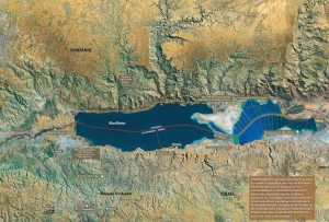
Local turístico apreciado por suas virtudes terapêuticas, o mar Morto está ameaçado de morte, numa situação ecológica “catastrófica” que pode levar a seu desaparecimento até 2050, advertiram os analistas.

Os “Amigos da Terra”, uma organização não-governamental do Oriente Médio que reúne ecologistas israelenses, palestinos e jordanianos, advertiram nesta semana sobre o perigo de uma “catástrofe ecológica” no mar Morto, onde desemboca o rio Jordão em meio a uma paisagem austera, queimada pelo sol e carregada de história bíblica.

“Em 50 anos, o mar Morto perdeu um terço de sua superfície e seu nível de água continua diminuindo rapidamente”, declarou Gideon Bromberg, do Amigos da Terra.

Situado a 412 metros abaixo do nível do mar Mediterrâneo, o mar Morto –que passou a ser chamado assim a partir do século 2– tem uma extensão de 50 km e 17 km em sua parte mais larga. É famoso por ter as águas mais salgadas do mundo, com uma salinidade de 33%, que equivale dez vezes a dos oceanos, o que permite a vida apenas de seres unicelulares primitivos, os procariontes, que não têm um núcleo definido.

A importante evaporação de água de sua superfície foi compensada até agora pelas águas do Jordão. No entanto, o desvio do caudal do rio por motivos agrícolas, Mar Mortohidroelétricos ou de consumo humano, além da construção de diques de evaporação para a exploração dos sais minerais ocasionaram uma diminuição do nível da superfície em torno de um metro por ano há mais de duas décadas.

“No momento não se estabeleceu nada de concreto para enfrentar a situação”, explicou Bromberg, enfatizando que o mar Morto perdeu 98% da partilha de água doce do Jordão, que se transformou num “verdadeiro conta-gotas”.

As consequências são especialmente graves para a parte costeira de Israel, ao sul do mar Morto, e palestina, concretamente a Cisjordânia, na parte norte.

Anualmente aparecem novas fendas que obrigam às autoridades proibir o acesso a partes inteiras do litoral, enquanto que os centros de cura e bem-estar que exploram as fontes termais, como o de Ein Gedi, sul de Israel, viram como o mar se afastou cerca de dois quilômetros. “Constatamos 1.650 buracos e fendas, algumas deles de várias dezenas de metros de profundidade”, assegurou o geólogo Eli Raz, especialista em mar Morto.

Quase todos os buracos se encontram em zonas de acesso proibido ao público e, em princípio, não ameaçam a segurança das infraestruturas turísticas e hoteleiras da região. Os buracos e as fendas ocorrem por causa da infiltração da água da chuva que dissolve os sais subterrâneos.

A situação política atual tampouco contribui para a colocação em andamento de medidas de vigilância e proteção. Em julho de 2005, o Banco Mundial anunciou que a Jordânia, Israel e a Autoridade Palestina conseguiram o financiamento de um estudo de factibilidade de um gigantesco projeto para construir um canal de união entre o mar Vermelho e o mar Morto.

Com uma duração prevista de 24 meses e um custo de US$ 15,5 milhões, o estudo obteve financiamento do Japão, Estados Unidos e alguns países europeus como a França, Itália, Noruega e Suécia.

No entanto, a vitória eleitoral do grupo radical palestino Hamas nas legislativas de 25 de janeiro implicaram o corte de qualquer relação entre Israel e a Autoridade Palestina, o que torna praticamente impossível a cooperação israelense-palestina no setor do meio ambiente.

O projeto, além disso, não conta com o beneplácito dos ecologistas, que temem uma perturbação do equilíbrio natural do mar Morto, levando em conta que se proporcionaria água salgada ao invés da doce como a do Jordão.

Por isso, se nos próximos anos não forem tomadas medidas sérias, os especialistas asseguram que o mar Morto estará seco em 2050.

Fonte: Marius Schattner, da France Presse, em Israel – Folha Online: 16/04/2006

Encontrada a verdadeira nascente do rio Nilo?

Team says it finds new source of Nile

By Arthur Asiimwe – Sat Apr 1, 5:30 AM ET

Nyungwe Forest, Rwanda (Reuters)

Surviving a rebel attack and braving crocodile-infested waters, a group of explorers has completed an 80-day voyage down the world’s longest river reaching what they say is the source of the Nile. The three explorers from Britain and New Zealand claim to be the first to have traveled the river from its mouth to its “true source” deep in Rwanda’s lush Nyungwe rainforest. “History has been rewritten,” British explorer Neil McGrigor told reporters on Friday. “This is the end of an 80 day amazing and exhausting journey.” (…) The team, which used a Global Positioning System (GPS), believes the Nile is at least 107 km (66 miles) longer than previously thought (cont.)

Equipe diz ter encontrado nova nascente do Rio Nilo em Ruanda

Sobrevivendo a um ataque rebelde e águas infestadas de crocodilos, um grupo de exploradores completou uma viagem de 80 dias pelo rio mais comprido do mundo e chegaram a um local que identificaram como a nascente do Nilo. Os três exploradores da Grã-Bretanha e Nova Zelândia dizem ter sido as primeiras pessoas a viajarem do delta do rio até sua “verdadeira nascente”, no meio da floresta Nyungwe, em Ruanda. “A história foi reescrita”, afirmou o britânico Neil McGrigor na sexta-feira. “Este é o fim de uma jornada de 80 dias.” A expedição, chamada de “Subindo o Nilo”, viajou por 6.700 quilômetros em três barcos, indo do Mar Mediterrâneo até onde dizem ser a nascente do rio. McGrigor e os neozelandeses Cam McLeay e Garth MacIntyre sofreram um ataque rebelde no norte da Uganda, que matou uma pessoa da equipe. Eles também se depararam com crocodilos antes de chegarem ao seu destino final. O debate sobre a verdadeira nascente do Nilo ocorre desde 1850, quando exploradores começaram a procurá-la [Obs.: link quebrado].