Estou lendo trechos do livro de KALIMI, I. ; RICHARDSON, S. (eds.) Sennacherib at the Gates of Jerusalem: Story, History and Historiography. Leiden: Brill, 2014, XII + 548 p. – ISBN 9789004265615.
Resumi os pontos principais do capítulo 4 sobre a tomada de Laquis.
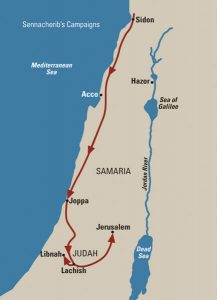
O capítulo foi escrito pelo arqueólogo David Ussishkin, que escavou Laquis, e trata da campanha de Senaquerib em Judá em perspectiva arqueológica com ênfase em Laquis e Jerusalém.
Na maior parte das vezes apenas traduzi alguns trechos ou organizei em outra ordem as palavras do autor. Vou publicar estas anotações em 3 posts que abordam:
1. Laquis na época da campanha de Senaquerib
2. O ataque assírio a Laquis
3. Os relevos de Laquis
O texto original em inglês é transcrito na íntegra, no final, mas retirando as notas de rodapé e as referências às imagens que ilustram o livro.
USSISHKIN, D. Sennacherib’s Campaign to Judah: The Archaeological Perspective with an Emphasis on Lachish and Jerusalem. In KALIMI, I. ; RICHARDSON, S. (eds.) Sennacherib at the Gates of Jerusalem: Story, History and Historiography. Leiden: Brill, 2014, p. 76-79, diz:
Laquis na época da campanha de Senaquerib
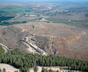
A elevação onde ficava Laquis (Tell ed-Duweir) tem cerca de 7 hectares. As encostas são muito íngremes devido às enormes fortificações da cidade antiga construída aqui. Escavações extensas foram realizadas em Laquis por três expedições arqueológicas. As primeiras escavações foram conduzidas em larga escala entre 1932 e 1938 por uma expedição britânica dirigida por James Leslie Starkey. Em 1966 e 1968, Yohanan Aharoni, na época na equipe da Universidade Hebraica de Jerusalém, realizou uma pequena escavação no ‘Santuário Solar’ do período persa. Finalmente, escavações sistemáticas, de longo prazo e em larga escala, foram dirigidas por David Ussishkin, do Instituto de Arqueologia da Universidade de Tel Aviv, entre 1972 e 1993.
Durante a primeira metade do século IX a.C., um dos reis de Judá construiu ali uma formidável fortaleza, transformando Laquis na cidade mais importante de Judá depois  de Jerusalém. Como não há inscrições, não se sabe qual rei construiu a cidade e em que data isto foi feito. A cidade fortaleza continuou a servir como a principal fortaleza real dos reis de Judá até sua destruição por Senaquerib, em 701 a.C.
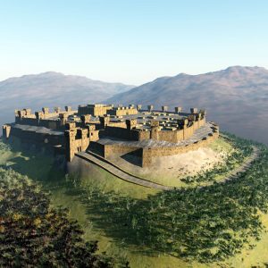
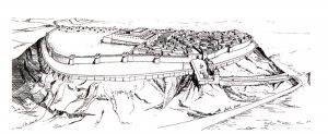
A cidade fortaleza, quase retangular, era protegida por duas muralhas: uma externa, ao redor do local, no meio da encosta, e a muralha principal da cidade se estendendo ao longo da borda superior do local. A maciça muralha externa foi descoberta na íntegra pela expedição britânica. Somente sua parte inferior, construída de pedras, foi preservada. Já a muralha principal foi construída de tijolos de barro sobre fundações de pedra. Com mais de 6 metros de espessura e cerca de 5 metros de altura, seu topo proporcionava espaço suficiente para os defensores se movimentarem e lutar.
Uma estrada levava do canto sudoeste do local até a antiga porta da cidade. O complexo da porta da cidade incluía, na verdade, duas portas: uma externa, ligada à muralha externa, e uma interna, ligada à muralha principal da cidade. E havia um pátio aberto e espaçoso entre as duas portas.
Da porta interna uma estrada levava ao palácio-forte que ficava no cume da elevação. O palácio-forte servia como a residência do governador real e como base para a guarnição.
Muito pouco se sabe sobre o palácio-forte, pois apenas suas fundações abaixo do nível do solo foram preservadas. A estrutura das fundações se assemelha a uma grande caixa que se eleva acima da superfície circundante. Algumas partes das paredes externas da estrutura da fundação foram expostas nas escavações. Essas paredes têm cerca de 3 metros de espessura. O piso do edifício se estendia no topo das fundações. É claro que um edifício magnífico e monumental se ergueu na época acima dessas fundações. Um grande pátio e dois outros edifícios foram anexados ao palácio-forte. Parece que um dos edifícios era um estábulo e que uma unidade de carros ficava estacionada ali.
Um poço profundo, principal fonte de água da fortaleza, estava localizado próximo à muralha da cidade, no canto nordeste. Aparentemente, fornecia quantidades  suficientes de água durante os períodos de paz e de guerra. A parte superior do poço era revestida por blocos de pedra e a parte inferior era escavada na rocha. O poço tem 44 metros de profundidade e ainda continha água quando os arqueólogos britânicos o descobriram na década de 30 do século XX.
A cidade foi completamente destruída por um incêndio em 701 a.C. quando Laquis foi conquistada pelo exército assírio. Parece razoável supor que, após o ataque bem-sucedido à cidade, soldados assírios com tochas nas mãos passassem sistematicamente de casa em casa e incendiassem tudo. Os restos da destruição foram encontrados onde quer que as escavações atingissem os prédios públicos e as residências particulares. As casas eram em grande parte construídas com tijolos de barro, e o fogo foi tão intenso que os tijolos de barro secos ao sol foram queimados e, em alguns casos, pode-se observar como as paredes das casas desabaram. Os pisos das casas foram encontrados cobertos com uma camada de cinzas, vasos de cerâmica quebrados e vários utensílios domésticos – todos enterrados sob o desabamento.
Lachish on the Eve of Sennacherib’s Campaign
Tel Lachish (Tell ed-Duweir), the site of the biblical city, is one of the largest and most prominent ancient mounds in southern Israel. The mound is nearly rectangular, its flat summit covering about 18 acres. The slopes of the mound are very steep due to the massive fortifications of the ancient city constructed here. Extensive excavations were carried out at Lachish by three expeditions. The first excavations were conducted on a large scale between 1932 and 1938 by a British expedition directed by James Starkey. In 1966 and 1968 Yohanan Aharoni, at that time on the staff of the Hebrew University of Jerusalem, conducted a small excavation, limited in scope and scale, in the ‘Solar Shrine’ of the Persian period. Finally, systematic, long-term and large-scale excavations were directed by me on behalf of the Institute of Archaeology of Tel Aviv University between 1972 and 1993.
 During the earlier part of the ninth century b.c.e., one of the kings of Judah constructed here a formidable fortress city, turning Lachish into the most important city in Judah after Jerusalem. With the absence of inscriptions, it is not known which king built the city and at what date. The fortress city continued to serve as the main royal fortress of the kings of Judah until its destruction by Sennacherib in 701 b.c.e.
The nearly rectangular fortress city was protected by two city-walls—an outer revetment surrounding the site at mid-slope, and the main city-wall extending along the upper periphery of the site. The massive outer revetment was uncovered in its entirety by the British expedition. Only its lower part, built of stones, was preserved. It probably served mainly to support a rampart or glacis which reached the bottom of the main city-wall. This massive wall was built of mud-brick on stone foundations. Being more than 6m (20ft) thick, its top provided sufficient, spacious room for the defenders to stand and fight.
A roadway led from the southwest corner of the site to the ancient city-gate. The gate is the largest, strongest and most massive city-gate known today in the Land of Israel. The city-gate complex included in fact two gates: an outer gatehouse, connected to the outer revetment, and an inner gatehouse, connected to the main city-wall, and an open, spacious courtyard extending between the two gates.
From the inner gate, a roadway led the way to the huge palace-fort complex which crowned the center of the summit. The palace-fort served as the residence of the royal Judahite governor and as the base for the garrison.
The palace-fort is undoubtedly the largest and most massive edifice known today from ancient Judah. Very little is known about the building proper, as only its foundations below floor level have been preserved. The structure of the foundations resembles a big box rising above the surrounding surface. Some parts of the exterior walls of the foundation structure were exposed in the excavations. These walls are about 3m (9ft) thick. The spaces between the foundation walls were filled with earth and the exterior walls were supported by an earth rampart. The floor of the building extended at the top of the foundations. It is clear that a magnificent, monumental edifice rose at the time above these foundations. A large courtyard and two annexed buildings were attached to the palace-fort. It seems that one of the buildings was a stable, and that a unit of chariots was stationed here.
 A deep well, which formed the main water source of the settlement, was located near the city-wall in the northeast corner of the site. Apparently, it provided sufficient quantities of water during times of peace and siege alike. The upper part of the well was lined by stone blocks and the lower part was hewn in the rock. The well is 44m (132ft) deep and still contained water when the British archaeologists uncovered it.
The city of Level III was completely destroyed by fire in 701 b.c.e. when Lachish was conquered by the Assyrian army. It seems reasonable to assume that following the successful attack on the city, Assyrian soldiers holding burning torches in their hands walked systematically from house to house and set everything on fire. The remains of the destruction have been encountered wherever the excavations reached the public buildings and domestic houses of Level III. The domestic houses were largely built of mud-brick, and the fire was so intense that the sun-dried mud-bricks were baked and colored, and in some cases it can be observed how the walls of the houses collapsed. The floors of the houses were found covered with a layer of ashes, smashed pottery vessels and various household utensils—all buried under the collapse.
